
Covid-19 risk mapping and population movement studies along Uganda-Rwanda borders in Ntungamo District, Uganda-Tanzania borders in Isingiro District, and Masaka District, Uganda, May 2020
Quarterly Epidemiological Bulletin : April to June 2020 Volume 5 Issue 2 Article No. 4
Authors: Job Morukileng1, Geoffrey Amanya1, Alex Ndyabakira1, Bob Omoda Amodan1, Lilian Bulage1
Institutions
1Uganda Public Health Fellowship Program, Ministry of Health, Kampala, Uganda
Corresponding Author: Job Morukileng, Email, jmorukileng@musph.ac.ug Mobile: +256782611585
Summary
Population mobility and connectivity facilitates movement and introduction of pathogens through infected travelers. Therefore, understanding population movement and connectivity patterns and how this relates to COVID-19 transmission is vital for planning and designing control strategies. In this study, we adopted the Centre for Disease Control and Prevention (CDC) Population Connectivity Across Borders (PopCAB) toolkit to assess and characterize population movement and connectivity patterns along the border districts of Ntungamo, Isingiro and Masaka/Kyotera. We identified seven landing sites, 15 trading centers, two streets in Masaka Town, 8 health facilities, 20 POE (5 official and 15 illegal) and one refugee settlement as areas of interest for mobile populations and the local communities. Our results further demonstrate that, transporters (truck drivers and boda bodas), sex workers (in Nyendo and Rubaare); traders/vendors on highways and trading centers, restaurant attendant’s, health workers (mainly in Masaka RRH), car mechanics (in Nyendo) and refugees, are high-risk groups. We recommended targeting priority areas and populations with interventions such as mass screening for COVID-19, strengthened community-based surveillance systems, risk communication, reinforced security at points of entry, provision of essential supplies, delayed opening of concentrated places such as schools, markets, places of worship and public transport.
Background
Human movement is associated with infectious diseases transmissions. As transport networks continue to expand in reach and speed of travel, pathogens and their vectors can now move further and faster than ever before. [1]. The current example is the significant contribution of human mobility to the spread of COVID-19 from Wuhan, Hubei province in China where it was first reported to the entire world[2]. As of 29 May, nearly four in five confirmed cases in Uganda were imported from the neighboring countries[3]. However, much of the Ugandan border remains porous, posing a risk of entry of unauthorized persons. As with the original SARS-CoV epidemic of 2002/2003, predictive risk mapping using population travel data, and tracing and mapping super-spreader trajectories are proving vital for timely and effective epidemic monitoring and response[2]. However, in Uganda, population movement and connectivity are not well understood, yet the government was in the process of lifting travel restrictions. We conducted COVID 19 risk mapping and population movement and connectivity patterns along border districts of Ntungamo and Isingiro in the southwest and Masaka District in Central Uganda to inform control and prevention measures
Methods
We assessed Corona Virus Disease (COVID-19) risk and population movement patterns using the Population Connectivity Across Borders (PopCAB) toolkit, a CDC innovation, in Uganda’s southwestern border districts of Ntungamo and Isingiro, and Masaka District in central Uganda. We conducted Key Informant Interviews (KIIs) with the district leadership involved in the COVID 19 task force, and district security and intelligence, including, the Resident District Commissioners (RDC), District Internal Security Officers (DISOs), District Surveillance Focal Person, and District Police Commanders (DPCs). These were purposively selected based on their role in national security and COVID-19 pandemic response. The KIs guided the identification of priority areas and participants for focused group discussions (FGD) at community level. We identified the long-distance truck drivers, motorcycle riders, local leaders, business people, sex workers, and farmers in priority locations to participate in the FGDs. Through a participatory approach, all important places and routes of interest before and after COVID-19 cross border movement restrictions and lock down, were plotted on the local district maps. After FGDs, we took GPS coordinates for important places of interest identified during the discussion. We further took guided walks at the Point of Entry (POE) and identified priority areas in order to observe the on-going activities.
Results
In Isingiro district, we identified the following areas of interest: Nakivale refugee settlement (hosting Congolese, Rwandese, Burundians and other nationals who move in and out of the
country through porous borders); Kamwema POE, Endiizi Trading Centre (close to the border and hosts illegal entrants), and Bugango and Kikagate POE. The populations identified to be at risk included Refugees, business people/venders in the POE and along the routes from POE to Isingiro Town, health care workers (in Nakivale health center III, Rwambaga health center III and Kikagate health center III), and Truck drivers.
In Ntungamo District, Mirama hills POE, Sofia Town (border town with several illegal entry points), Kizinga POE, Ngoma Trading Centre( close to the border with large farms that employ illegal entrants from Rwanda), and Rubaare Town Council (known for sex workers and the main stopping point for truck drivers) were identified as areas of interest for the populations. The Truck drivers; sex workers (in Rubaare town); illegal immigrants from Rwanda (youth); the matooke farmers and business people/venders in the POEs and along the roads were identified as the most at-risk groups.
The areas of interest identified in Masaka District included Nyendo Town Council (known for sex workers, vehicle garages, washing bays, and bars and lodges), Hobat and Budu streets (main destination for produce and general merchandise trucks from Tanzania, Rwanda, Kenya and within Uganda), the Masaka Regional Referral Hospital (the main treatment center for COVID-19 cases and other diseases), landing sites in Bukakata and Marembo, and Kalisizo Trading Centre a long Mutukula POE-Masaka road. We identified the following categories of people as the most at risk in Masaka District, drivers for fish and other cargo trucks; sex workers (mostly in Nyendo); health workers; wholesalers in Budu and Hobat streets (Masaka town); mechanics mostly in Nyendo, restaurant and bar attendants and passion fruit, tomatoes and pineapple farmers in the growing villages of Marembo and Bukakata.
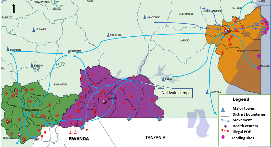
Figure 1: Map showing population movements in Isingiro, Ntungamo, and Masaka Districts, May 2020
Discussion
Although the lock down and the closure of border crossings significantly minimized movements in the Uganda and through the legal Points of Entry, the people in Southwestern border districts of Ntugamo and Isingiro continue interacting with Rwandese, Burundians and Tanzanians through the porous borders. Persons from neighboring Tanzania who enter through illegal routes, mainly access nearby villages to visit relatives and to buy and sell goods. The Rwandese similarly cross to nearby villages to visit relatives but also look for work in farms. Some proceed to the refugee settlement at Nakivale in Isingiro District.
Although Masaka District is not directly bordering any country, Tanzanians can access Masaka District directly through Lake Victoria. Masaka is also a converging point for the main routes originating from the Southwestern border district and is the exit point towards the capital Kampala. Masaka is a large town with major schools, hotels, garages, large wholesale shops, restaurants, and health care facilities, making it a main destination for the travelers and the population from neighboring districts. Being a converging and stopping point means that Masaka District continues to receive a significant amount of traffic even during lock down which puts the district at a heightened risk for transmission of COVID-19 virus.
The study results show that the populations remain mobile and interconnected at district and regional scale even in amidst of lockdown. By mapping these population movements and connectivity, especially for the border districts, a valuable evidence base to guide disease surveillance as well as control and elimination planning can be improved. In this study, we identified seven landing sites, 15 trading centers, two streets in Masaka Town, 8 health facilities, 5 official points of entry, and 15 illegal POEs, and one refugee settlement as areas of interest for mobile populations and the local communities. Interactions in the priority/areas of interest increases risk of infection among the transporters (truck drivers and boda bodas), sex workers, traders/vendors on highways and trading centers, restaurant attendant’s, health care workers, security officials; famers (for tomatoes, matoke, passion fruits and pineapples), car mechanics and refugees.
Conclusion
Although the lockdown has minimized population movement and connectivity in the districts under study, cross border interactions continue through the porous borders and legal POE. This interaction translates into increased risk of COVID-19 importation and transmission in the identified areas and populations.
Recommendations
We recommend that the MoH and health implementing partners target the priority areas and categories of people with tailored COVID-19 interventions such as; COVID-19 mass testing, risk communication; improved community based surveillance; providing supplies to priority locations; Delaying opening areas of concentration such as markets, schools, public transport, and places of worship in the hot sports and increasing deployment of security in illegal POE to minimize unauthorized cross border movements.
References
- Tatem, A.J., D.J. Rogers, and S.I. Hay, Global transport networks and infectious disease spread. Advances in parasitology, 2006. 62: p. 293-343.
- Boulos, M.N.K. and E.M. Geraghty, Geographical tracking and mapping of coronavirus disease COVID-19/severe acute respiratory syndrome coronavirus 2 (SARS-CoV-2) epidemic and associated events around the world: how 21st century GIS technologies are supporting the global fight against outbreaks and epidemics. 2020, BioMed Central.
- Uganda, M.o.H., COVID-19 Situation Report#103, 29/05/2020 update, accessed on 2020/05/29. available at https://veoci.com/veoci/p/w/f/abgy41atnue1t6r4/Ug_COVID-19_Sitrep%23103_+29May2020.pdf
![]()
. 2020.
Comments are closed.